Military/Intelligence Bulletin 1/2018 – North Korean Missile Threat.

What is North Korea’s current missile capability?

North Korea’s increasingly frequent missile tests are signalling their improving capability in the region and sending warning signals to the US and its Allies, in the main South Korea and Japan.

.

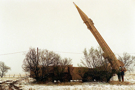
The KN-02 Toska, is a North Korean reverse-engineered locally produced short-range ballistic missile, provided by the Soviet Union via Syria. No serious threat to South Korea, Japan or the US a range  of less than 200km.

Photo-credit. Created by the Center for Nonproliferation Studies for the Nuclear Threat Initiative.

.

Scud-B, a tactical ballistic missile developed by the Soviet Union. North Korea obtained its first Scud-B’s from Egypt in 1979/80. Again reverse-engineered, then reproduced at the 125 factory at Pyongyang and the research and development institute at Sanum-dong and the Musudan-ri launch facility. Known as the Hwasong-6, and with a range of up to 300km, this does pose a threat to South Korea.

.

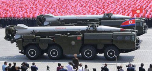
The Hwasong-6, a modified Scud-C, has a much greater range, 500km. With this range, it is capable of just reaching the coast of Japan.

.

The Hwasong-7, an Extended Range Scud on the other hand, launched by the North Korean’s on the 6 March 2017, with a range of 1,000km, went beyond the coast of Japan. For the first time, the Iwakuni air base in western Japan was in range of North Korean missiles.

The Nodong1 and Pukgeuksong 2 increased the range further to 1,700km.

.

The Hwasong-12, launched on the 28th August 2018, changed the game completely. With a range of 2,700km, it was only a few hundred kilometres short of Guam, an unincorporated and organised territory of the United States.

A further Hwasong-12 missile was launched on 14th September 2017, reaching a staggering 3,700km, well beyond the island of Guam.

.

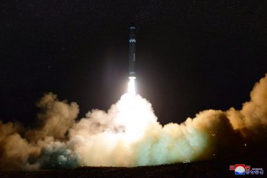
Image credit – Rodong Sinmun

In November 2017, the Hwasong-15 ballistic missile was launched and reached a ceiling of just under 5,000km, theoretically capable of reaching the United States mainland.

The pace of North Korea’s nuclear and missile programme continues along with the rhetoric behind it. Although progress continues, North Korea’s Intercontinental Ballistic Missiles are still under development and their is still some doubt about the credibility of their nuclear deterrent.

Post copyrighted to Harvey Black


Military/Intelligence Bulletin 02/2017 – Russian Satellite capability in decay?

What is the current state of Russia’s satellite fleet?

Although the Russian Federation is attempting to upgrade its satellite capability, at the moment it is small and very outdated.

Since the fall of the Soviet Union, Russia has suffered a serious deterioration of its satellite signals intelligence and radar imaging capability.

.

The Kondor-E synthetic aperture radar satellite, the export version of the original Kondor, which no longer appears to be operational.

Kondor-E-Synthetic aperture radar satellite. image credit: NPOMash


September 2015, saw the last descent of a Russian Yantar 42KM photoreconnaissance satellite. This, a Kobalt-M series, was the last of its type that sent back its pictures to earth in a return capsule.  Whereas the US and China last used this type of film-return satellite back in 1986 and 2005 respectively, switching to digital imaging satellites.


Yantar-42KM

The US launched the first of its Kennen (later called Crystal) satellites that used CCD technology as early as 1976, launching a further 14, of which four are still in orbit.


Image from a KH-11/Crystal satellite of the construction of a Kiev-class aircraft carrier (1984).  Janeskh11leakedphoto 

.

It has taken Russia many years to catch up with the West. It wasn’t until after 1983 that Russia developed a satellite camera that was able to come close to the Kennen. Russia had 10-20 of these new generation satellites, but by May 2001, all of these had been de-orbited, leaving Russia without any digital reconnaissance satellites in space.

In July 2008, Russia launched the first of its Persona satellites, Kosmos-2441. Russian media reported its loss only two months later as a consequence of the memory boards in the on-board computer crashing due to charged particles.

The next one, Kosmos-2486, fitted with hardened electrical components, was launched into orbit in June 2013, but soon encountered problems and was crippled by software issues by November 2013. This problem may have been resolved by the following year.


Persona satellite (Kosmos 2486) Image By w:User:-=HyPeRzOnD=- – 

.

The third Persona, Kosmos-2506, was launched in June 2015.  If the two currently operational satellites survive their expected life of seven years, they could deliver images until 2020 and 2022.

Russia’s new generation of satellites are due to be launched in 2019, 2022 and 2024, but the current western imposed sanctions could delay this as Russia would need to find replacements for western imported electronic components. Meanwhile, Russia has introduced digital topographic mapping satellites, one in 2015 and one in 2016 (design-life of 5 years). Four more are believed to be under construction.


.

Resurs-P non-military Earth observation satellite. image credit: TsSKB

.

Russian military can also make use of civilian remote sensing satellites. Although of a low resolution, they could help to identify, for example, fighter aircraft types parked up on airfields. They currently have access to three of the above Resurs-P satellites.

.

As well as electronic-optical satellites, Russia also operates synthetic aperture radar satellites, especially to provide imagery at night and through cloud cover. The Soviet Union first launched radar-equipped satellites in the late 1980s, but the programme collapsed with the fall of the Soviet Union. Their next launch, Kosmos-2487 (Kondor), was in June 2013. Although observations have shown no manoeuvres have been completed by the satellite since September 2015, the suspicion being that it may not be operational.

.

Strela Space Rocket, used to launch the Kondor satellites. Photo: Roscosmos

.

After a recent visit to ISS Reshetnev by the Russian minister of defence Sergei Shoigu, several photographs taken by a TASS reporter, and later released, revealed a potential new, until then unknown, Russia satellite. A Repei (burdock) S and a sister satellite, Repei-V. The belief is that these will be used as either communication satellites or signals intelligence satellites.

Repei-V.   Photo: Business Wire

Just a brief insight into the status of Russian satellite capability. It is a huge subject which requires detailed research to fully understand where Russia currently sits in the intelligence gathering area.  since the collapse of the Soviet Union 25 years ago, Russia has finally started to field a new generation of satellites, but is still way behind the US and China in both numbers and performance.

Post copyrighted to Harvey Black


Military/Intelligence Bulletin 01/2017 – South China Sea.

Conflict? Will Vietnam and China face up to each other in the South China Sea?

Is Vietnam becoming increasingly concerned with China’s policy in the South China Sea?

.

Spratly Islands – South China Sea. By Voice of America 

What does Vietnam need to protect?

Thirty plus Islands for a start, including Spratly Island itself.  But with a coastline of over 3,000 kilometres, it has a major seafood industry to secure. Therefore it is imperative that it maintains control of its coastline and occupied islands.

Oil. The Gazprom Group (with Russian interests) is dipping a toe in at Vietnam’s request. Gazprom International is currently hydrocarbon prospecting in the area of Vietnam and the South China Sea. It is already engaged in developing oil and gas blocks on the shelf of the South China Sea. In the area of the Islands, the aggregate reserves are estimated to be 55 billion cubic metres of natural gas and 21 million tons of gas concentrate.

What about China?

There is an ongoing territorial dispute between the People’s Republic of China, the Philippines, Malaysia, Taiwan and Vietnam concerning the ownership of the Spratly Islands group.

The motivation for China’s actions in the South Sea has three strands. Their primary one is that of defence, flexing its military muscle. Then comes resources, followed by pure self-interest. During the last century, China has continued to stake a claim on the islands situated in the South China Sea.

Both countries have artificially expanded their territory around the spratly islands. Vietnam has extended Sin Cowe island, probably trebling it in size. Now with a small harbour, helipad, sensor post and defensive positions.

China on the other hand, is reinforcing the Paracel archipelago. The militarisation of the largest of the Islands, known as Woody Island, 300 km southeast of Hainan in China, continues. There is an airport, port, and even a hospital, school and library. Dredging, land reclamation and construction on and around the island continues. In 2015, Beijing temporarily deployed fighter aircraft to Woody Island.

Fiery Cross Reef is also being expanded.


Fiery Cross Reef


What is Vietnam’s response?

China retains a significant military advantage over Vietnam, so the country needs to bolster its defensive and offensive capability.

A number of investments have been made. The Bastion-P anti-ship missile system is based on its southern coast and has a range of 300km. This only protects the coastline, but if moved to Spratly Island, its 300km range would cover China’s Fiery Cross Reef and other islands occupied by them.

Vietnam troops operating the Russian made Bastion-P anti-ship missile.

Although not yet operational, the four Kilo class SSK submarines, purchased from Russia, with the Klub cruise missile, could pose a significant threat to Chinese occupied locations.

Hanoi Kilo 636

.

Klub cruise missile (range 220km). By Allocer – Own work, CC BY-SA 3.0


Both countries operate the J-11B fighter aircraft, which would allow China to cover the entire group of islands, including the Paracels to the north. Vietnam would be able to threaten the same area.


J-11B Flanker, air superiority aircraft.


China’s counter to this, is the HQ-9, medium to long-range surface-to-air missile, with a range of 200km. Deployed to Fiery Cross Reef, puts Spratly Island in range.

HQ-9 Surface-to-Air missile TEL. By Jian Kang – 2009.beijing.

Just a brief insight into what may be brewing in the South China Sea. The conclusion being that there are a number of triggers for conflict in the South China Sea.

Competition over marine resources: hydrocarbons and fish.

Oil: Vietnam wanting the Spanish energy company, Repsol, to drill appraisal wells 270km offshore. China Has leased the same area of sea to a Hong Kong-based company, Brightoil. A conflict in the making.

State claims: Due to the large number of competing state claimants there is a real possibility of an incident emerging that could develop beyond the control of the leadership in Beijing.


Spratly Island

Post copyrighted to Harvey Black


Deception (Cold War – Redux – 2) now available. 

I have recently written the first of two novels in my latest Apocalyptic series, ‘Force Majeure – Purgatory’ and ‘Force Majeure – Paralysis’. The third in the series will be out later this year. Prior to these two books, I wrote a Cold War trilogy, The Red Effect, The Black Effect and The Blue Effect, portraying what I believe could have happened in the 1980’s, had the Soviets, and the Warsaw Pact, taken the decision to attack West Germany and plunged the world into a third world war.

I now ask myself the question, are we heading down that very route now? To answer that, I have just finished writing the second book in a new Cold War trilogy, or the ‘Cool War’ as it is sometimes referred to. Deception (Cold War Redux – 2) is now available for pre-order.

Deception (Cold War Redux – 2), out now for pre-order.

.

Flag_of_Ukraine.svg

.

The flag of Ukraine.

.

IMG_1197

Zaporizhia, a mere 50 kilometres from a Nuclear Power Station.

.

Zaporizhia Nuclear Power Station with 6 Nuclear Reactors (Google Maps).

.

Top right, the concrete cylinders storing nuclear waste.

.

IMG_0523

My journey to Mariupol would skirt the occupied area of Donetsk, hence the heightened security.

.

IMG_0474

Security on the route to Mariupol was exceptionally tight, my English passport always raising eyebrows and requiring considerable explanation from my escorts. This trip though, I was actually going to meet one of their colonels, a commanding officer a Border Guard Regiment.

.

IMG_1812

Mariupol is a large industrial port city on the shores of The Sea of Azov, a population of nearly half a million. The ethnic population is equally split between Russian and Ukrainian. This is the landing zone used by Spetsnaz Force -1.

.

IMG_1816

The coast to the south. This is the landing zone used by Spetsnaz Force -1.

.

IMG_1781

Two vehicles of the Mariupol detachment of the Security Service of Ukraine

.

IMG_1795

This is the home of the Mariupol detachment of the Security Service of Ukraine. The Sluzhba Bezpeky Ukrayiny, SBU.

.

IMG_1780

The building was raided in February 2014, and numerous documents, hard drives and other data were stolen or destroyed. The raid was allegedly ordered by President Viktor Yanukovych.

.

IMG_1302 (1)

The 79th Parachute Brigade are legendary. They fought extensively in the Battle in Shakhtarsk Raion where they secured the Russian border and the strategic Savur-Mohyla hill.

.

IMG_1303

In September 2014, the 79th joined the 3rd Separate Spetsnaz unit and National Guard Units in the defence of Donetsk Airport. Due to their stubborn resistance, they were referred to as ‘Cyborgs’.

.

IMG_1300

As they are one of the Quick Reaction Forces, QRF, in the region, they are at a permanent state of readiness. While sat inside, i quickly discovered that the object my foot was resting on was and anti-tank mine. Apart from the standard turret mounted 14.5mm KVPT machine gun, the vehicle I was in carried an AGS-17 grenade launcher. They also had at least half a dozen light anti tank weapons. All vehicles were stocked up with large stocks of water, food and ammunition, so would be able to sustain operations for a number of days in order to prevent a Russian intrusion into the Mariupol Zone.

.

IMG_1301

This is one very professional unit and is more than capable of giving any enemy a bloody nose.

.

Trench lines east of Mariupol and west of Shyrokyne (Google Maps).

.

HarveyBlack FM1 Concept3

Don’t forget, Duplicity (Cold War Redux – 2), is now available.

.

.

Site and content, including photographs, is copyrighted to Harvey Black.